
The Southern States 200 Georgia Course Description
By Aid Station
The Course - Georgia, Section by Section
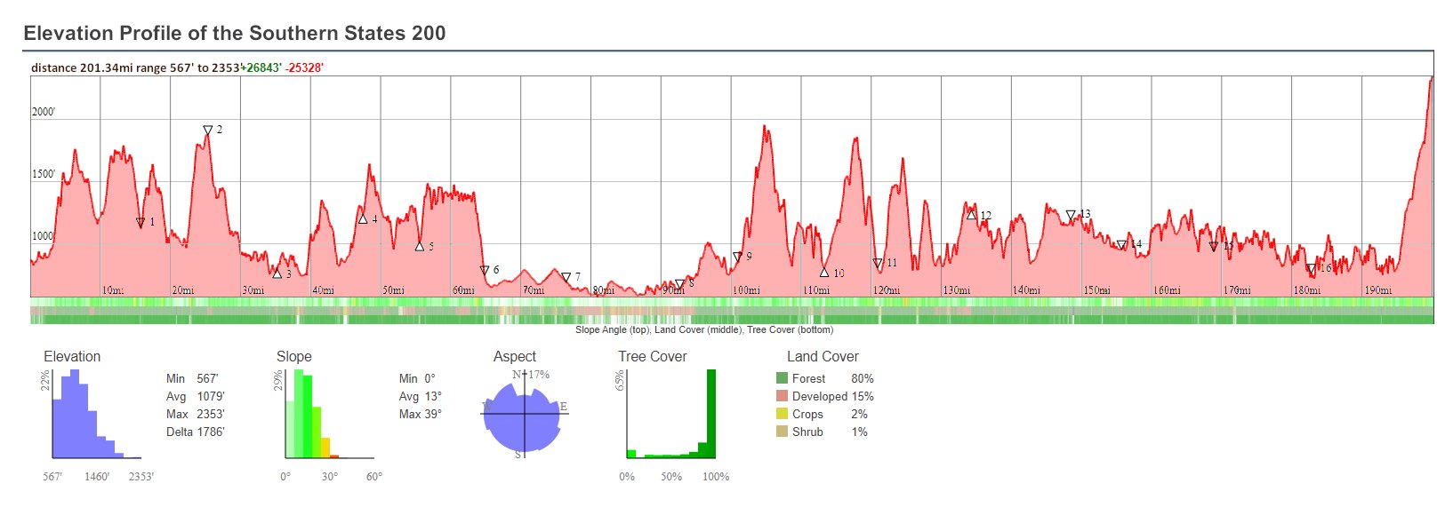
The Southern States 200 has 16 aid stations. The first 9 aid stations are located in Georgia. We will provide runners with a detailed description of each section, divided by aid stations. We will include feet of ascent and descent, type of trial and trail surfaces along each section, as well as a turn-by-turn description. This section and the Alabama section will be frequently updated. Check the “Last Updated” date to see if there have been recent changes.
The course is rugged. The first 70 miles in in the North Georgia mountains. This is one of the most beautiful sections of the Pinhoti Trail. Most of this section is on single track trails. After the High Point Aid and Sleep Station, the run takes a break from the mountain.
Runners will be on a rails-to-trails section for about the next 14 miles. This is not a paved section and is single or double track all the way to the Big Tex Aid Station.
The next section, to Cave Spring is mostly on back roads with minimal traffic. This will be a great recovery section, if runners resist the temptation to increase their pace too much.
Shortly past Cave Spring, the run moves back into the mountains on trails. Other than a few hundred yards on a paved section of the Chief Ladiga Trail and another 1/3 mile section crossing over I-20, there are no more paved road sections.
Aid Station Distance and Elevation


Section 1 - Rocky Face Start at Mill Creek to Snake Creek Gap - 0.0 to Mile 16.20
Aid Station Crew and Drop Bags
Detailed Description of Each Section
Aid Station to Aid Station
Last updated: 3/5/2024
Section 3 - John’s Overlook to the Dry Creek Trailhead Aid Station, Mile 25.91 to 39.11

Leave the John’s Mountain aid station heading north on the gravel road. Follow the road downhill for 1.5 miles. The Pinhoti trail leaves the road heading to the left. Runners will be on single-track trails for the next 2.5 miles then switch to double-track for 1.5 miles. At about mile 32, you will enter a section of mixed-use trails for mountain bikes and hikers/runners for the next 5 miles Theses trails are single-track or double-track trails. Shortly before mile 39.1, you will reach the Dry Creek Equestrian Trailhead. The aid station will be located in the pavilion to the left as you enter this large trailhead. Vault toilets are directly in front as you enter the aid station.
There is no crew access to John’s Mountain Aid Station.
Distance Between: John’s Mtn and E Armuchee - 13.2 Miles, Cumulative Miles - 39.11 Miles
Elevation Change: Ascent - 1,151 ft., Descent - 2,240 ft.
Packed Gravel/Dirt Double-Track: John’s Mountain - 1.5 Miles, Near mixed section - 1.6 miles. Total 3.1 miles
Single-track Trails: 10.5 miles.

(The Narrows Picnic minimal aid station is included in Section 4)
Section 4 - Dry Creek to Mack White Gap Aid Station - Mile 39.11 to 59.81
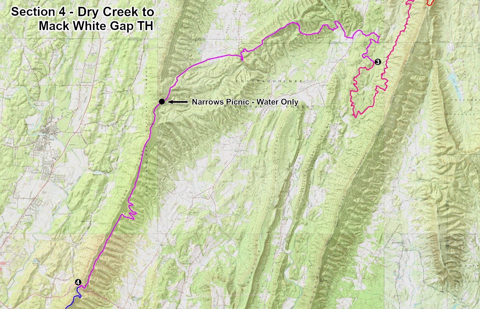
After the aid station, follow trails and gravel roads for 2.71 miles to East Armuchee Road. Go left for 0.3 mile, then turn right on Manning Mill Rd for 0.8 mile. (East Armuchee and Manning Mill Rd are paved.) Take the gravel road leading off to the left and immediately cross West Armuchee Creek at a water crossing with cement blocks for steps. Be careful here, the blocks may be slippery. The Pinhoti goes left about 50 yards past the creek. Runners will be on single-track trails for the next 3.3 miles. There the trail switches to closed double-track for one mile to West Armuchee Rd. at about mile 43.
At W. Armuchee Rd., go left (south) down the paved road for 0.2 mile. Turn right onto The Narrows Road and immediately cross a bridge over Ruff Creek. After 1.8 miles on the paved road, the pavement ends and runners will continue on packed dirt/gravel for 1.5 miles. At the split, go left on an old dirt road for 0.2 mile. The single-track Pinhoti goes to the right, leaving the dirt road. The Pinhoti trail stays on single-track trails for the next 2.8 miles. There runners will enter a one mile stretch of closed forest road, then back to single-track for 2 miles. Six miles past West Armuchee Rd, (12.40 miles past Dry Creek Aid Station) runners will reach the Narrows Picnic Aid Station at mile 51.51. It will be a water only or possibly a minimal aid station. Runners then switch to another closed forest road for 1.5 miles to where you pass through gate and follow a packed gravel/dirt road for about one mile. From there, the trail is single-track to Mack White Gap Trailhead.
Mack White TH is a crew accessible aid station. The trailhead is small and we may limit crew access.
Distance Between: Dry Creek and Mack White Gap TH - 20.26 Miles, Cumulative Miles - 59.81 Miles
Elevation Change: Ascent - 2,894 ft., Descent - 2,680 ft.
Paved Road: East Armuchee Rd 0.3 Miles, Manning Mill Rd - 0.8 mile, W. Armuchee - 0.2, The Narrows Rd - 1.4 miles. Total Paved Miles- 2.7 miles
Packed Gravel/Dirt Double-Track: The Narrows Rd 1.4 Miles, to W. Armuchee - 1 mile, to Mack White - 4 miles. Total Gravel/Dirt - 6.5 Miles
Single-track Trails: 8.4 miles.

Section 5 - Mack White Gap to High Point Chattahoochee Aid Station - Mile 59.81 to 69.31
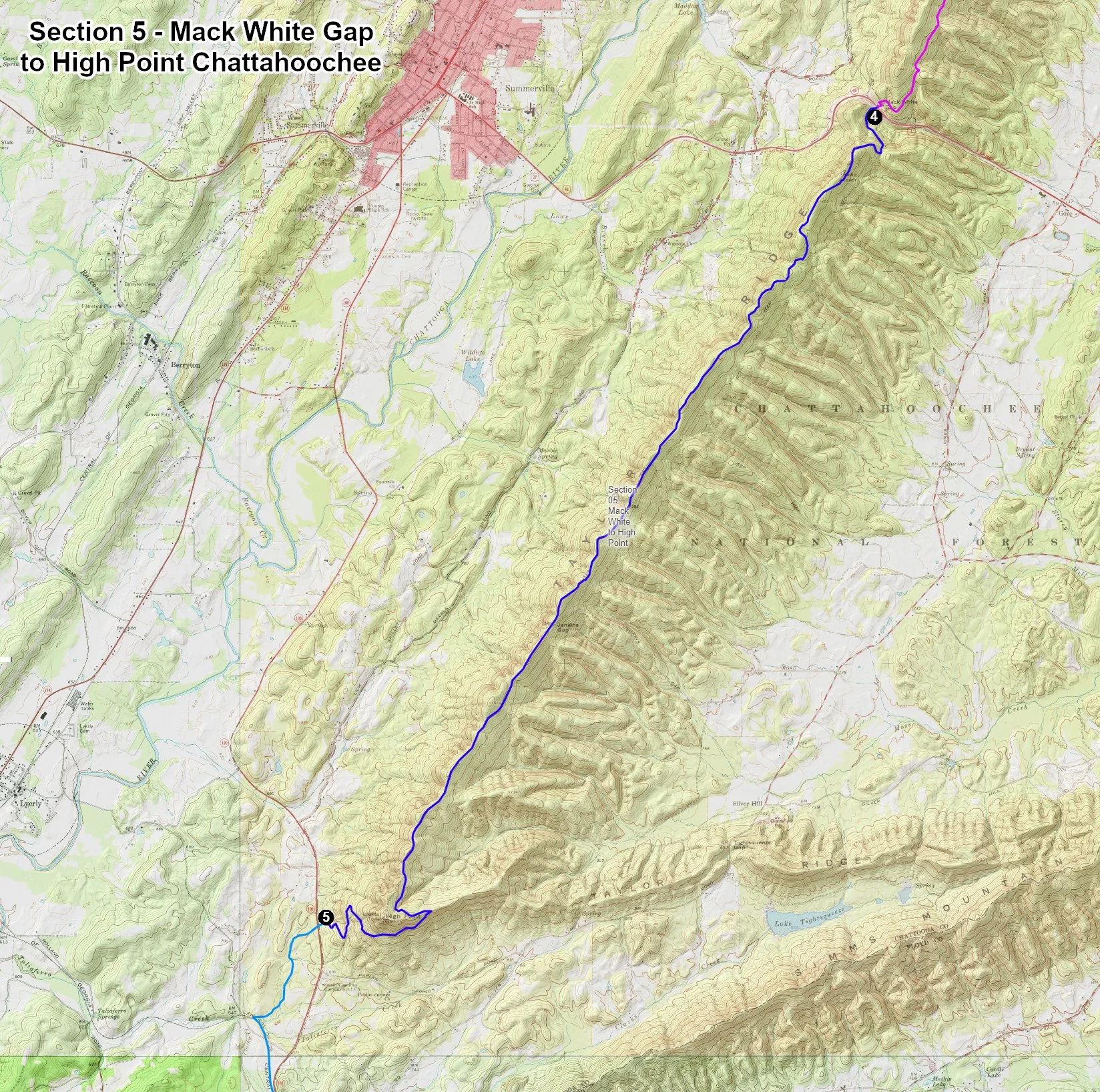
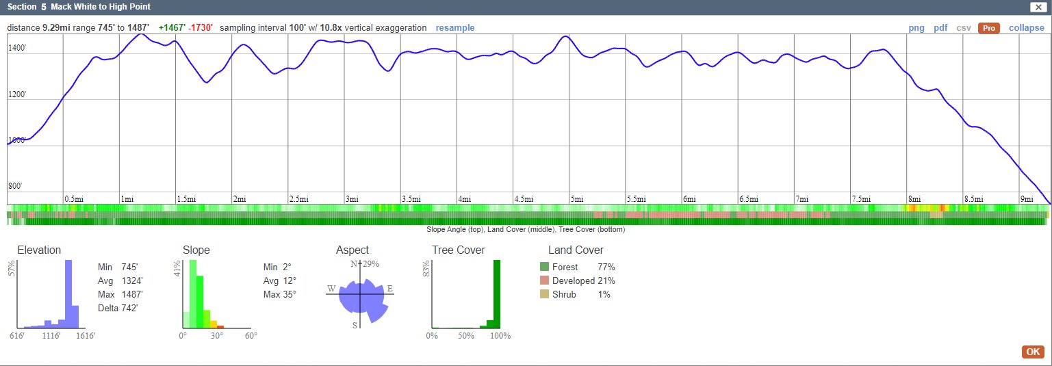
Leave Mack White Aid Station heading southeast up a gravel road for 1/2 mile to the split. Go left up another gravel road for 0.4 mile to the fire tower. Go left into the single-track trail at the tower. Runners will be on the single-track trails all the way to the High Point Chattanooga Aid and Sleep Station at mile 66.7. There are two short double-track sections along the ridge, about 1 mile total.
High Point will be the first Sleep Station. We will have a heated 10X20 tent with Sleeping bags and sleeping pads. Drop Bags are available for all Sleep Stations and we highly recommend packing a sleeping bag in your dropbag if you plan to sleep in the sleep station. The sleeping bags provided may not be sufficient to keep you warm.
High Point Chattahoochee TH Aid and Sleep Station is a crew accessible aid station.
Distance Between: Mack White Gap and High Point - 9.50 Miles, Cumulative Miles - 69.31 Miles
Elevation Change: Ascent - 1,467 ft., Descent - 1,730 ft.
Packed Gravel/Dirt: Total - 0.9 miles
Single-track Trails: Total - 8.6 miles
Section 6 - High Point Chattahoochee to Big Tex Aid Station - Mile 69.31 to 81.21

Leave the High Point Chattahoochee Aid and Sleep Station heading west, straight across Georgia 100. The trail begins directly across from the trailhead. The next 12 miles to Huffaker Rd is on a hard-packed dirt trails. Follow a single-track trail for 1.1 miles to where it joins a Rail-Trail section. Runners will be on the double-track Rail-Trail for the next 11.3 miles. The Pinhoti Trail joins the Simms Mountain Rail-Trail at about mile 79. The Simms Mountain Rail-Trail ends when it connects into Huffaker Road, 0.7 mile past the Big Tex aid Station. The aid station is at mile 81.21.
The Big Tex Aid Station will be located where the Simms Mtn. Rail-Trail crosses Big Texas Valley Rd. The Aid Station will be on your left after crossing the road.
Distance Between: High Point and Big TEX Aid Station - 11.90 Miles, Cumulative Miles - 81.21 Miles
Elevation Change: Ascent - 484 ft., Descent - 638 ft.
Packed Dirt Rail-Trail: Total - 10.8 miles
Paved Road: 0.0 Miles
Single-track Trails: Total - 1.1 miles

Section 7 - Big Tex to Cave Spring (Rolater Park) Sleep & Aid - Mile 81.21 to Mile 97.21
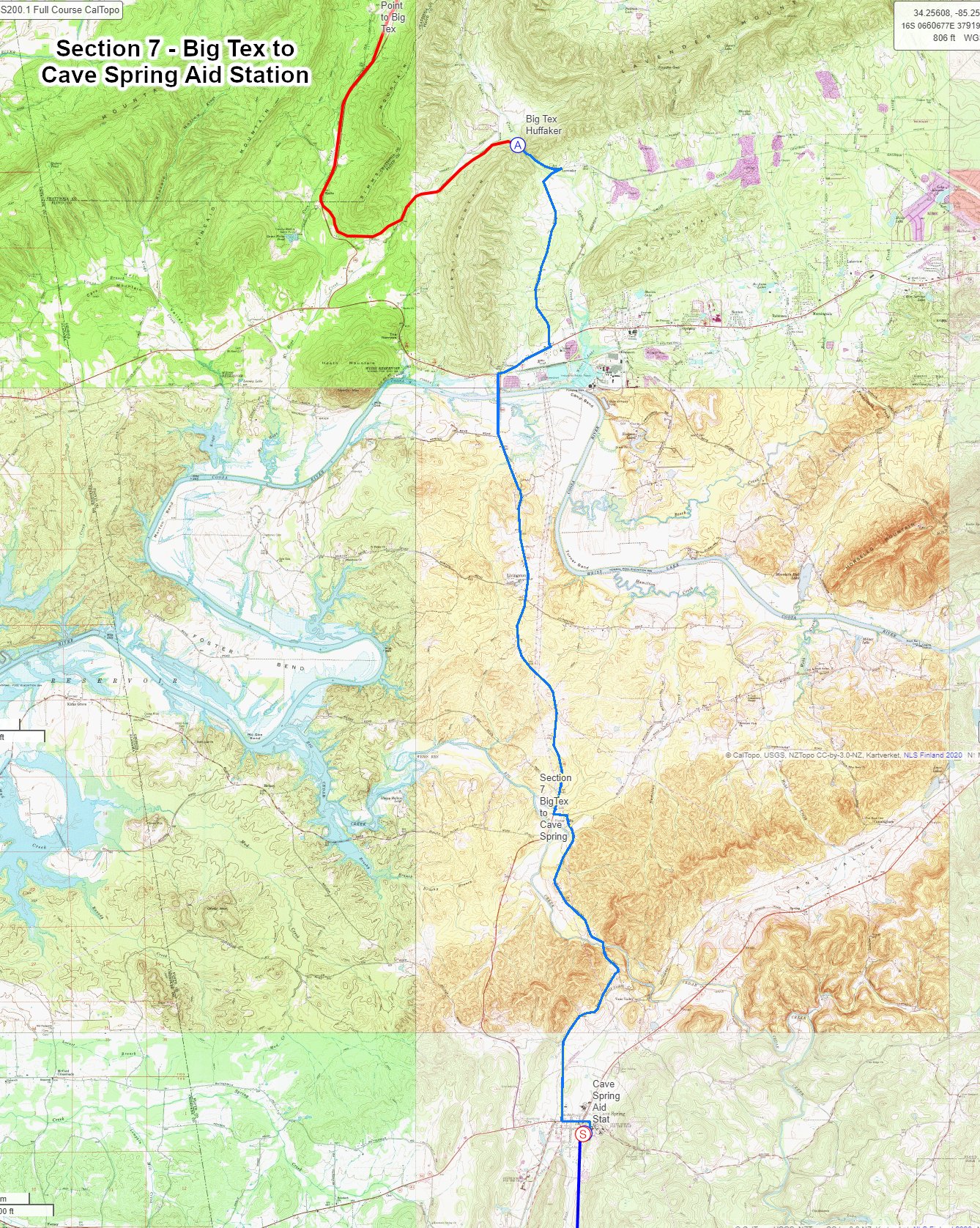

Leave the aid station and continue 0.7 mile on the Simms Mtn. rail/trail. Turn right on Huffaker Rd for 2.7 Miles to the intersection of GA 20, The Alabama Highway. Continue straight across GA20 and turn right. Runners must cross over GA 20 at the intersection of Huffaker Road and GA20. DO NOT continue down the right side of GA 20. Use caution crossing GA20. This is the only busy, Four-lane road you will encounter in the SS200. After crossing the highway go right (west) facing oncoming traffic, for 3/4 mile. At GA 100, Foster’s Mill Rd. Turn left and cross the long bridge over the Coosa River.
Just before reaching GA20 you will see “Even’s Deli and Auto Parts” on your right. I am not kidding! The deli is supposed to have good food and they are very “hiker friendly.” Your crew might want to grab a sandwich there. If you need any supplies is a good option since it’s just steps off the course. It is OK for runners to stop by a store or restaurant. It is not OK for your crew to pick up supplies for you.
Continue on GA 100 for 6 miles to Black’s Bluff Rd. Turn Left heading east for 200 yards, then turn right (south) on Spout Springs RD. Continue on Spout Sprints for 2.4 miles to a split. Go right at the split on Mills Rd SW for 2 miles. You are now in Cave Spring. Turn left on US 411 - Georgia Ave. Stay on Georgia Avenue through town to the stoplight. Continue straight ahead past the Cave Spring General Store on Georgia AV. (See the pictures below.) Stay on Georgia AV for 100 yds. and turn right into Rolater Park. Follow the road along the large swimming pool to your right, then angle right to the aid station. The aid station will be on your left in the Childers Pavilion.
The Cave Spring Aid and Sleep Station. This will be a full sleep station in a 10 X 20 heated tent.
Cave Spring is a crew accessible aid station. You may not get to enjoy Cave Spring, but your crew will!
Distance Between: Big Tex and Cave Spring Aid Station - 16.00 Miles, Cumulative Miles - 97.21 Miles
Elevation Change: Ascent - 700 ft., Descent - 751 ft.
Paved Roads: Total - 16 miles
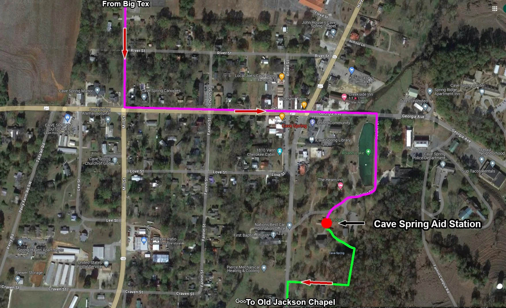
How to navigate through Cave Spring to reach the aid station in Rolater Park - See the photos below
Section 8 - Cave Spring to Old Jackson Chapel Aid Station - Mile 97.21 to 105.51
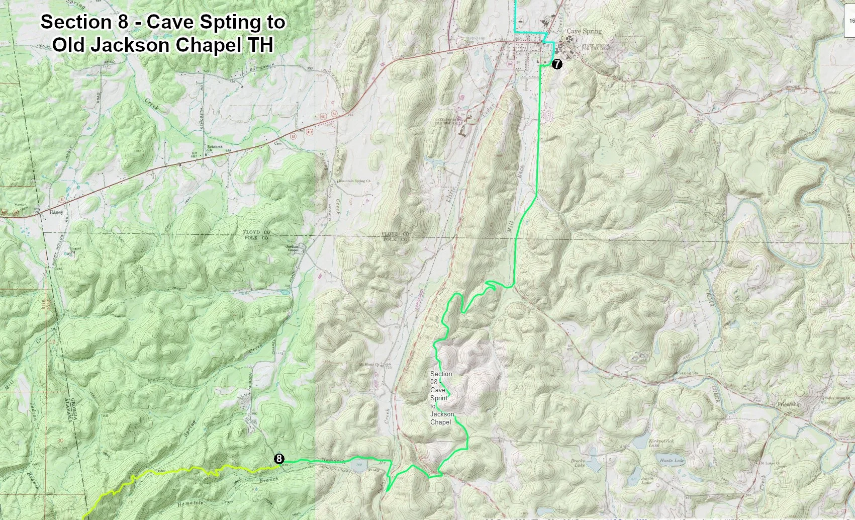
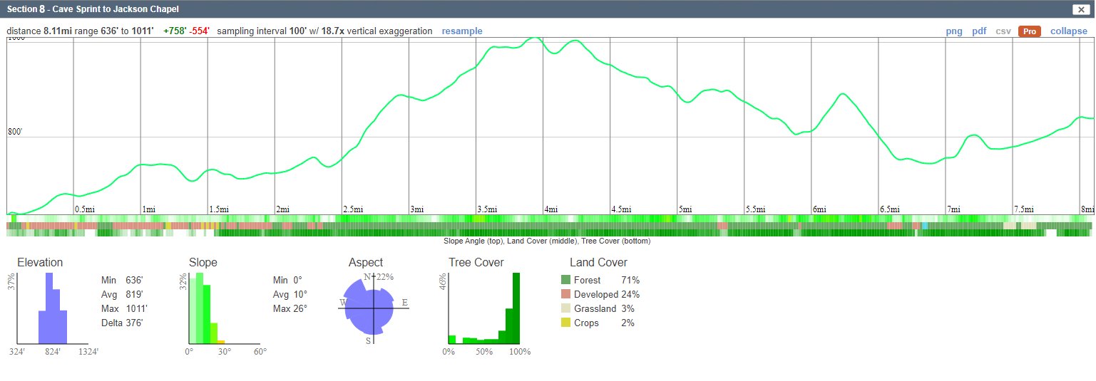
Runners will leave the Aid Station and follow the path through the park and turn left on Cave Springs RD (Old Cedartown Rd) for 2.51 miles. At the large trailhead, turn right on single-track trails for 5.9 miles to the Old Jackson Chapel Trailhead and the aid station. This is the final aid station before reaching the Georgia/Alabama line. The state line is 2.48 miles past the aid station.
There is no crew access at Old Jackson Chapel Aid Station.
Distance Between: Cave Spring to Old Jackson Chapel Aid Station - 8.30 Miles, Cumulative Miles - 105.51 Miles
Elevation Change: Ascent - 758 ft., Descent - 554 ft.
Paved Road: Total - 2.51 miles
Single-track Trails: Total - 5.79 miles
The ALABAMA/GEORGIA State Line - Mile 107.99
Section 9 - Jackson Chapel to High Point, Talladega (Alabama) - Mile 105.51 to Mile 118.31
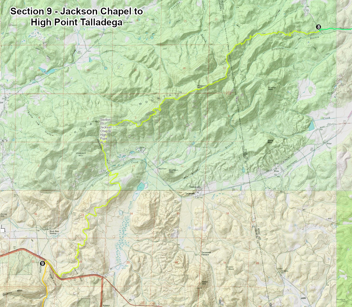

Runners will leave the Jackson Chapel Aid Station going due west. The next 12.80 miles will be on single-track trails for . Almost as soon as you leave the aid station you start the 1,136 ft. climb to the top Flag Mountain. You will be back in the mountains for the next 45 miles.
Distance Between: Old Jackson Chapel and High Point Talladega (Alabama) - 12.80 Miles, Cumulative Miles - 118.31
Elevation Gain: 2,586 Ft
Elevation Loss: 2,620 Ft
Single-track Trails: Total - 12.80 miles
The Race Start - Rocky Face, Georgia in the community of Mill Creek
The start is in the community of Mill Spring. The race will start in the parking lot of the Baptist Church directly across from the “Need Too Feed” Café and Deli. The start is exactly 4 miles from the Hilton Garden Inn just off College Drive in Dalton. The Hilton will probably be the race headquarters. There are a total of 12 major hotels within a mile of the Dalton Convention Center and the Hilton.


Getting to the Start: To get to the start from the Hilton Gardon on College Dr. in Dalton, turn left out of the parking lot heading south on College Dr. 0.3 mile to the light. Stay in the left lane. Turn left on Doug Gap Battle Rd and continue for 3.3 miles over the top of the ridge and back down the other side. Continue straight ahead on Hurricane Rd for 0.8 mile. The road “T” into Mill Creek Rd at the start. Need Too Feed is straight ahead.
NO CARS WILL BE ALLOWED TO PARK IN FRONT OF THE “NEED TOO FEED” CAFE AND DELI. THAT PARKING IS FOR CUSTOMERS ONLY! (BTW, THE SPELLING IS CORRECT. IT IS “TOO”)
Parking at the Start: Parking will be extremely limited at the start. If it rains, we will not be able to use the grassy areas behind Need Too Feed. That would eliminate most of the parking leaving only the parking area next to Need Too Feed and Mill Creek Baptist Church across the street.
NO CARS MAY BE LEFT AT MILL CREEK AFTER THE START!
Additional Parking: There is another Baptist Church 500 meters down the road to the north. Crews will be allowed to drop runners and drop bags off at the start before parking at the church.
Section 2 - Snake Creek Gap to John’s Overlook Aid Station, Mile 16.20 to Mile 25.91

Runners leave Snake Creek Gap at mile 15.77, cross GA 136 and continue for the next 9.61 miles on mostly single-track trails. At about mile 21.5 runners reach Pocket Rd. Turn left on the paved road for 0.1 mile, then back right on Keown Falls Road for 0.6 mile. At mile 22 you cross John’s Creek and begin a 1.6 mile, 900 ft. climb to the ridge above. In route, the Pinhoti Trail passes under Keown falls.
After the falls, the trail continues climbing for two miles along the ridgeline to John’s Mountain Overlook. The aid station has amazing views of the valley below. There is a vault toilet just before runners reach the aid station. If you reach the aid station before dark, take a minute to enjoy the view. If you arrive at sunset, it should be amazing. The overlook faces west.
There is no crew access to John’s Mountain Aid Station.
Distance Between: Snake Gap to John’s Mtn. Overlook AS - 9.71 Mile. Cumulative Distance in race - 25.91 Miles.
Elevation Change: Ascent - 1,927 ft. Descent - 1,171 ft.
Packed Dirt/Gravel Road Double-Track: Gentry Gap Rd - 0.2 mile, Keown Falls Road FS702 - 0.62 miles, John’s Mtn Rd - 0.74 miles. Total Dirt/Gravel - 1.56 Miles
Single Track Trails - 8.94 Miles


The Start: The race will start in front of the Mill Creek Baptist Church under the timing arch. Runners will follow Mill Creek Road for about 100 to 150 yards before angling to the left onto Hurricane Road. Runners will follow Hurricane Rd for 1.6 miles. Turn right onto Franklin Hill Rd for another 0.2 mile, then continue straight ahead on Ash Way. After another 0.3 mile, the road (using the word “road” here is questionable at best) ends at an old, unused forest road.
This is where the fun begins. The initial climb from the start is 1,117 feet. After that, there is a long descent followed by two more climbs. The total elevation gain for the first 15.5 miles is 1,942 ft. The first 8.5 miles of this section of the Pinhoti should be all single-track trials. For the next mile, down to Swamp Creek, runners will be on a hard packed double-track trails. For the final 7 miles, to Snake Creek Gap, runners will be on an abandoned dirt road that is about the same as single track.
Snake Creek Gap is located at a large trailhead. There is plenty of parking at the trailhead. This aid station will be very busy being so close to the start. We will have volunteers supervising parking. Your crew must use live tracking to know when you will arrive at the aid station. Your crew may not arrive at Snake Creek Gap more than 30 minutes before you, the runner, arrives.
If you arrive in the area early, find a safe place, away from the trailhead to park. There is a small Baptist Church about 1.4 miles north of the trailhead on GA 136. That’s the only place I see on Google Maps with a parking lot anywhere close by.
Distance Between Start and Snake Creek: Start to Snake Creek - 16.20 miles
Elevation Change: Ascent - 2,400 ft., Descent - 2,111 ft.
Paved Roads: 1.8 miles
Hard Packed Dirt Roads: 2.6 miles
Single-track trails or abandoned dirt road: 11.1 miles
