
The Southern States 200 Course
The Course
As stated earlier, the run is 200 continuous miles starting at Mill Creek, a small community in the town of Rocky Face, Georgia. Runners will finish on the highest mountain in Alabama, Mt Cheaha. This is not a stage race. When the race starts Wednesday, March 19th at noon, runners have 100 hours to finish. We will have 15 full aid stations along the way. Five of the aid stations will be Sleep Stations, with a separate heated tent, sleeping pads and sleeping bags. Each aid station will provide a variety of “real” made-to-order food. Of course, there will also be standard aid station food for those who love chips, cookies, PBJ sandwiches and candy. The race is sponsored by Tailwind so we will be serving Tailwind Hydration drinks at all aid stations. We will also have water, cokes, sprite, ginger ale and coffee.
While the Southern States 200 is not as difficult as some 200 milers, it’s still going to be tough! Much of the course is on rugged single-track trails. Runners will climb almost 28,000 feet along the way. The run is a true test of one’s endurance. You will need to put in many long hours of training and preparation to be ready to complete this adventure. If you are not willing to make the investment in sweat and time, don’t register. If you are, this will be an adventure you will never forget. That’s our promise to you.
Click on the image below to see the Course with CALTOPO

THE SOUTHERN STATES 200 Course

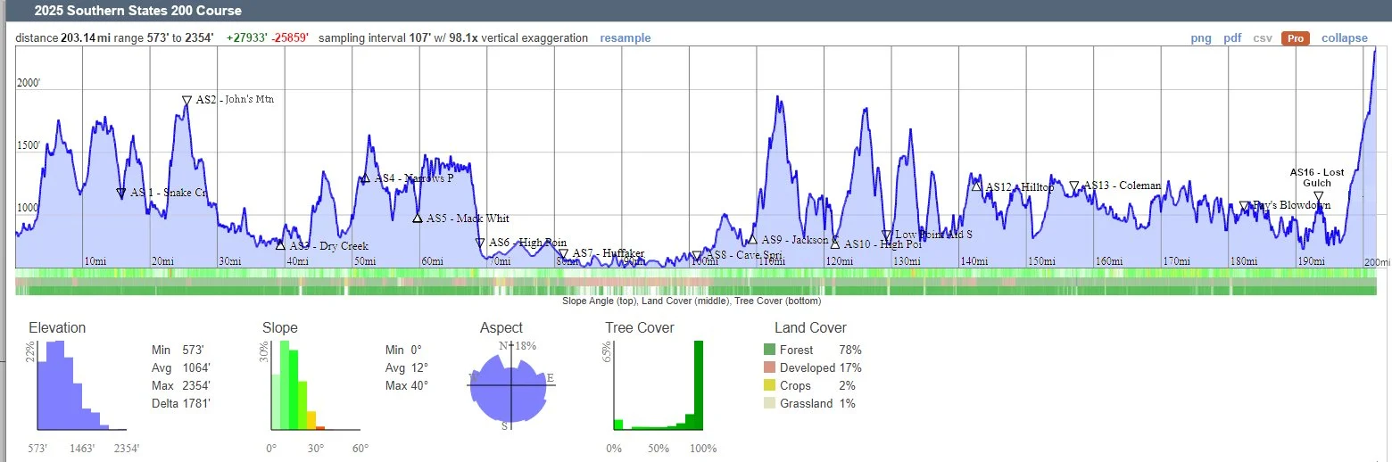
Below is the Southern States 200 Course Profile Generated by CalTopo

For information on downloading the SS200 GPX file to the GAIA App on your Android devices Follow this link.
(4)


(7)
(6)

(5)
Course Details
The first 70 miles in in the North Georgia mountains. This is one of the most beautiful sections of the Pinhoti Trail. Most of this section is on single and double track trails. After the High Point Chattahoochee Aid and Sleep Station, runners get a break from the mountains.
Runners will be on a rails-to-trails section for about the next 14 miles starting after High Point. This is not a paved section and it’s single or double track all the way to the Huffaker Road.
The next section, to Cave Spring, is on the original Pinhoti Trail and is paved. This road section has wide shoulders until reaching the back-roads close to Cave Spring, with minimal traffic. This will be a great recovery section, if runners resist the temptation to increase their pace too much.
Shortly past Cave Spring, the run moves back into the mountains on trails. Other than a few hundred yards on a paved section of the Chief Ladiga Trail and where the Pinhoti Trail crosses over Interstate-20, there are no more paved road sections all the finish at Bald Rock on Mt. Cheaha.
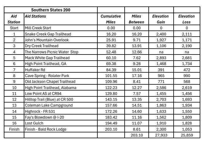
Aid Station Distance and Elevation
Click on image to open the expanded version
Almost every year we have problems with people messing with flags at our local races. Over the last two years we have purchased several game cameras and place them in strategic places around the course. We will use them at the Southern States 200 but the odds of catching anyone is slim at best. And, even if we do, the damage is done. To protect runners we require all runners to have the course on a navigation device. We suggest the GAIA GPS App for everyone. Download it to your phone and load the SS200 GPX file, above. (You are required to have a GPS navigation aid to run the SS200.) GAIA saves the file and cell reception is not necessary for the app to track your location on the course. The app will continuously show your location and proximity to the course. We will accept other GPS tracking devices and watches. You MUST know how to use the device you have. GAIA is a simple as it gets.
Here are the steps to download the course to GAIA on you iPhone:
First, download the GAIA GPS App to your phone.
Download the GPX file, above, to your computer.
Send an email to yourself with the GPX file attached.
4. Open the email on your phone.
5. Open the GPX File and click on the upload icon.
6. After clicking on the upload Icon, select the GAIA App.
.
7. The course will now be on your phone.
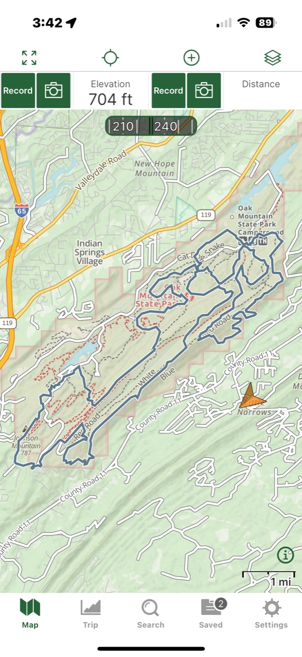
Don’t Panic! The course on image #7 is NOT the SS 200 course. It’s the Blood Rock 50 Mile loop at Oak Mountain State Park. The orange arrow shows your location in relation to the trails at the park.
Trail Marking
We will use a combination of Yard Flags, Flagging attached to clothes pins, Arrow Signs and Wrong Way Signs. We will alternate between the Flags and Flagging depending on what is best of the specific sections.
1. We use BLUE 3 x 5 YARD FLAGS to mark trails where possible. Virtually all flags used on the Southern States 200 course will have DOT prismatic reflective tape attached. They are easily spotted 200 or 300 yards away at night. (When we refer to flags, we are talking about both Flags and Flagging.)
2. We will place about 5 to 7 flags per mile along trails that are easy to follow and there is no place to make a wrong turn. On sections where the trail is indistinct, flags will be more dense. In confusing areas, flags may be line of sight. If you go more than 800 yards and don’t see a flag or flagging, check your GPS navigation device to see if you are still on course. If you think trail marking has been removed, please try to contact one of the emergency numbers on your bib and let us know.
3. Trail intersections will have multiple flags showing the way.
4. We place 9 X 12 Blue and White” Arrow Signs” at most trail changes. The signs will have Yellow DOT Reflective Tape on them. Trails that “T” into another trail will have flags heading off the correct direction. Follow the Flags!
5. Critical turns, that may be easy to miss, may have a Red & White 9 X 12 Wrong Way sign a short distance beyond the turn.
6. All trail changes and places that might be confusing have multiple flags visible as you approach the area. If you see 3 or 4 or more flags close together, wake up!! Something is about to happen.
8. Flags are places where they do the most good. They will usually be on the uphill side of the trail where they are most visible. Sometimes, they are simply placed where we can get them in the ground or where there is a bush to attach flagging.
9. There is ONE RULE above all others for the SS200 runners, FOLLOW THE FLAGS!!!! Where the flags go, you go.
10. There is a second rule. Don’t blindly follow the runner in front of you. You may both end up in Chattanooga!
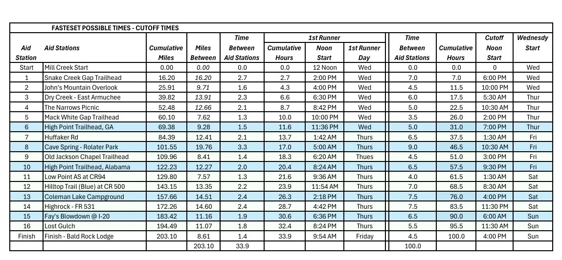
Pace Chart - Fastest Possible Times and Aid Station Cutoff times
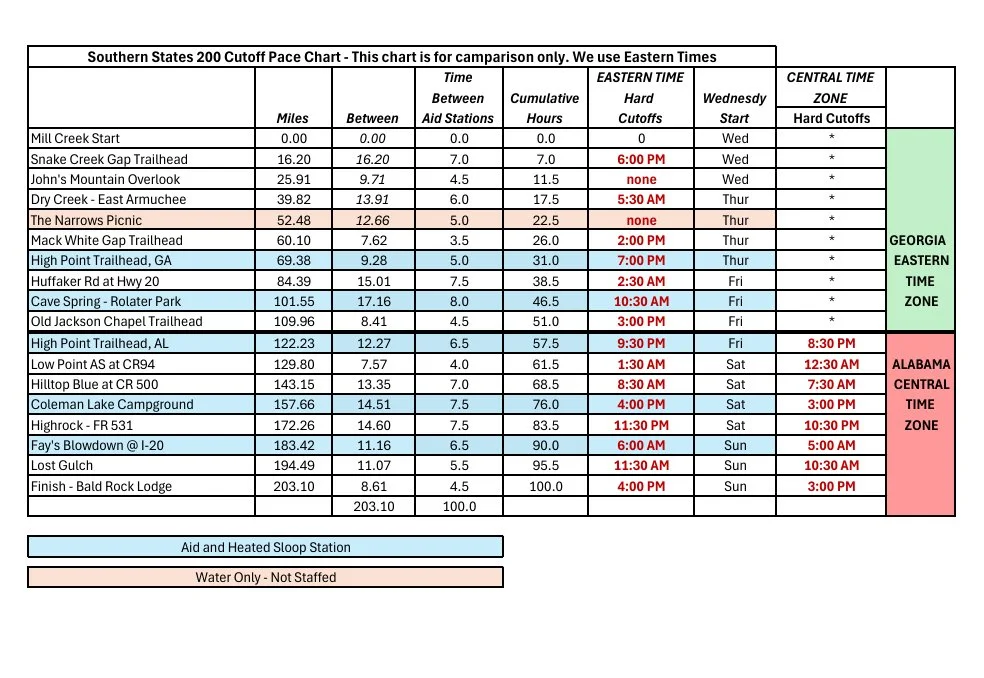
ABSOLUTE CUTOFF TIMES - ALL TIMES EASERN STANDARD TIME