The Southern States 200 Alabama Course Description
By Aid Station
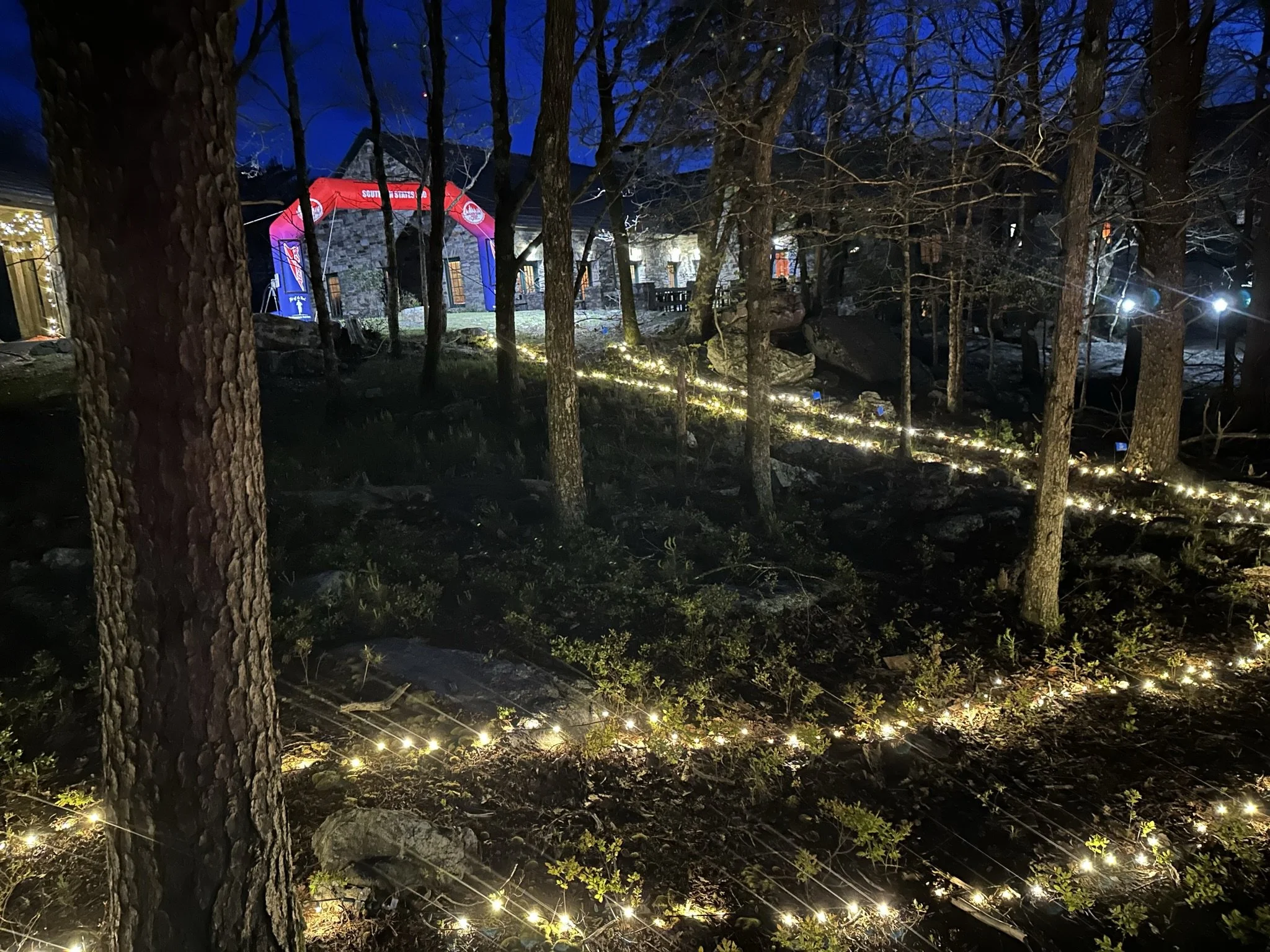
The finish of the Southern States 200 at Bald Rock Lodge on top of Mt. Cheaha, in Cheaha State Park.
The Course - Alabama, Section by Section
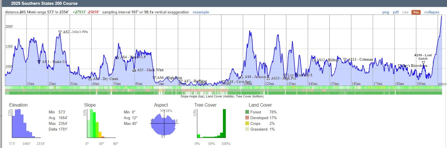
The Southern States 200 has 16 aid stations. The last 7 aid stations are in Alabama. We describe each of the Alabama sections on this page. We will provide runners with a detailed description of each trail section of the course, by aid stations. We will include feet of ascent and descent, type of trial and trail surfaces along each section, as well as a turn-by-urn description. This section may be updated from time to time. We will note the date of the latest updates
Please Remember, to avoid any confusion, all aid station times shown are Eastern Time. When you cross the Alabama State Line after Old Jackson Chapel aid station, you enter the Central Standard Time Zone. I would suggest setting you phone and watch to “Not Automatically” adjust when changing time zones.
PLEAES NOTE: IF YOU ARRIEVE AT A ROAD CORSSING, TRAIL CORSSING OR TRAIL SPLIT AND DON’T SEE ANY SIGNS OR FLAGS, GET OUT YOUR NAVIGATION MAP. SOMETHING IS WRONG.
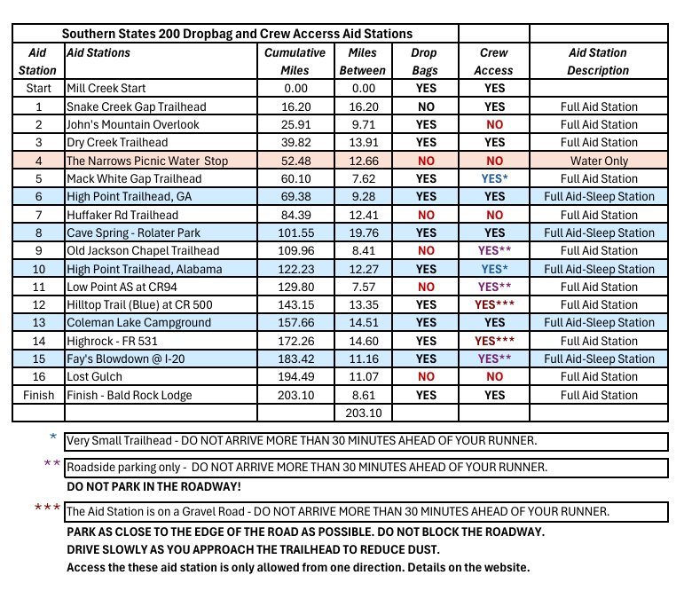
Aid Station Crew Access and Drop Bag Locations
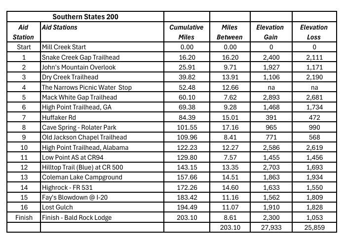
Aid Station Distance and Elevation
Detailed Description of Each Section
Aid Station to Aid Station - Alabama
Section 9 - Jackson Chapel to High Point , AL Aid & Sleep Station - Mile 109.96 to Mile 122.23
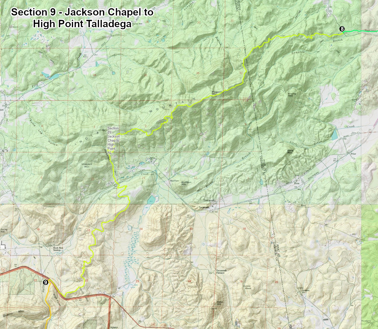
Runners will leave the Jackson Chapel Aid Station going due west. The next 12.27 miles will be on single-track trails. Almost as soon as you leave the aid station you start the 1,136 ft. climb to the top Flag Mountain. You will be back in the mountains for the next 45 miles.
Flag Mountain and Indian Mountain are the location of the Indian Mountain ATV park. The Pinhoti Trail is allowed to pass through this private land. Don’t be suppressed if, in the middle of the night, you top the mountain and see Psychedelic lights and hear loud music blaring. You are not hallucinating. Well, probably not anyway.
Distance Between: Old Jackson Chapel and High Point Talladega (Alabama) - 12.27 Miles, Cumulative Miles - 122.23
Elevation Gain: 2,586 Ft
Elevation Loss: 2,620 Ft
Single-track Trails: Total - 12.80 miles

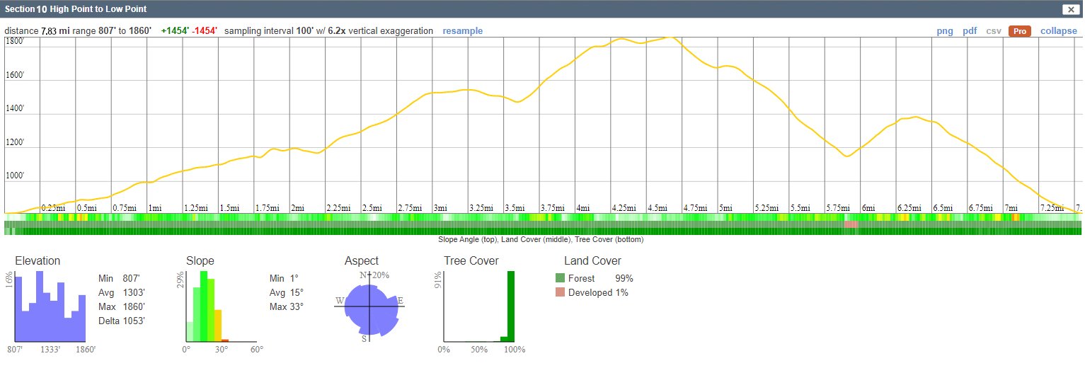
Section 10 - High Point, Alabama to Low Point at CR94 - Mile 122.23 to Mile 129.80
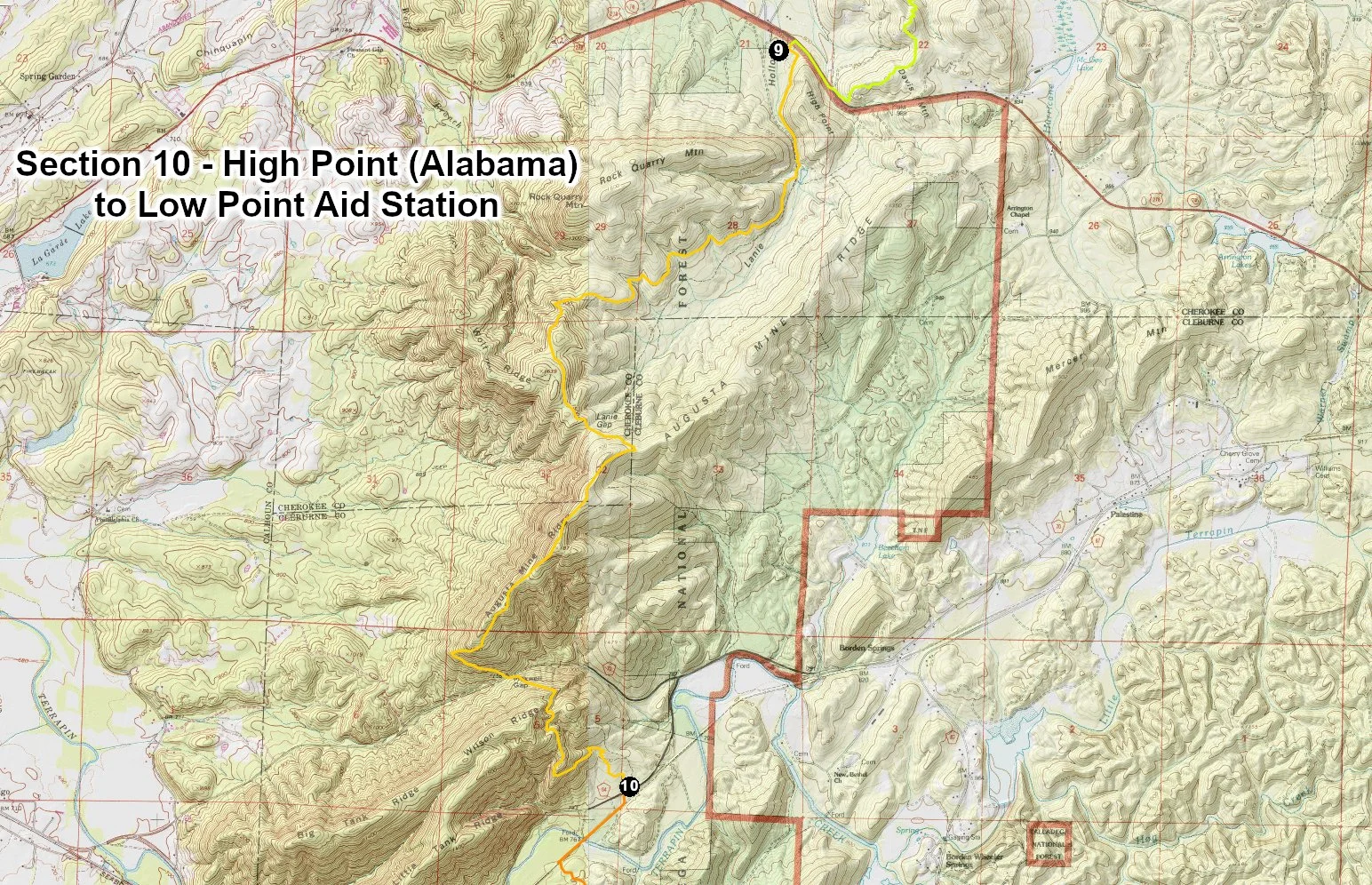
Right out of the aid station runners will start a 4.3 mile climb to the top of Agusta Mine Ridge. Then you will descend 1.5 mile to CR 70. Cross the road and start a ½ mile, 270 foot climb over another ridge before drop down to County Road 94 and the Low Point Aid Station. This section is all single-track trails. The aid station will be located in the right-of-way along CR 94 about 100 yards before reaching the Chief Ladiga Trail.
Distance Between: High Point Talladega and Low Point, CR 94 - 7.57 Miles, Cumulative Miles – 129.80
Elevation Change: Ascent – 1,454 ft., Descent – 1,454 ft.
Single-track Trails: Total – 7.83 miles
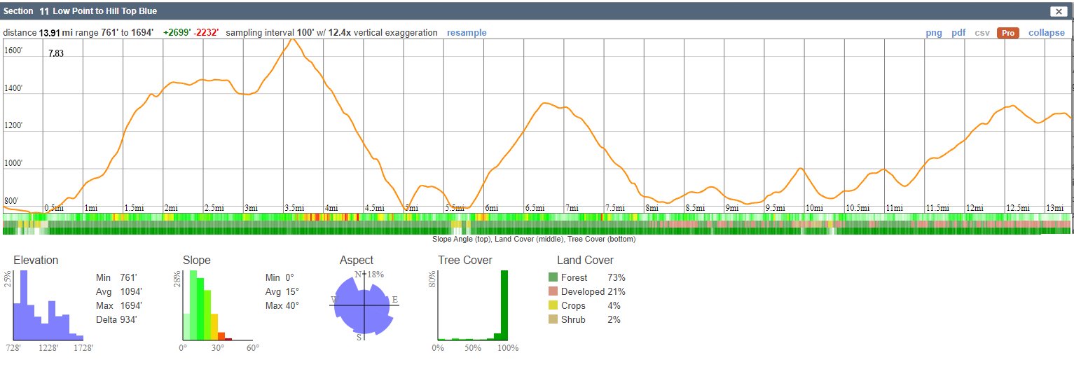
Section 11 - Low Point to Hill Top Blue Trail Aid Station - Mile 129.80 to Mile 143.15

Runners will leave the Low Point Aid Station heading south. After about 100 yards go right on the Chief Ladiga Trail. The Chief Ladiga is a paved Rail-Trail. Follow Ladiga southeast for 0.5 miles. The Pinhoti Trail turns off to the left, leaving the paved trail. The next 7.43 miles will be single-track trails. After 7.93 miles, runners reach County Rd 500. This is a hard-packed gravel and dirt road. At the road, turn left and follow 500 for 5.5 miles to the Hill Top/Blue Trail Aid Station.
After exactly two miles on the gravel road, runners will climb a small hill. At the crest of the ridge you will cross a paved road, CR 55. This road intersection is on top of a hill and sight distance is limited. There is not much traffic on CR 55 but be careful crossing the road. Also, we have had problems with the signs getting pulled up at the this intersection. This is private land. Do not turn right or left on the paved road. Continue straight ahead on the gravel road for 3.5 mile miles. If in doubt, check your GPS navigation device.
NOTE: Be sure your crew understands they my NOT drive on CR500 between Piedmont, AL and Hwy 55 (Rabbit Town Rd) or between Hwy 55 and the Coleman Lake Aid Station. If they do, you will be disqualified. Your crew is required to reach Coleman Lake and Hilltop Blue from the Georgia Side of the Pinhoti. Use the button below to see a map from High Point, Alabama to Coleman Lake.
Distance Between: Low Point, CR 94 to Hill Top Blue Trail at CR500 – 13.35 Miles, Cumulative Miles – 143.15
Elevation Change: Ascent – 2,703 ft., Descent – 1,693ft.
Hard Packed Dirt/Gravel Roads – 5.6 miles
Single-track Trails: Total – 8.5 miles
Section 12 - Hill Top Blue Trail to Coleman Lake Aid & Sleep Station - Mile 143.15 to Mile 157.66


Leave the aid station, go around the iron gate, heading up the Blue Trail to the north. This is a closed, hardpacked dirt road. The Hill Top Blue double-track Forest Road 540C continues for 3.42 miles to where it connects into FR540. Go around another iron gate and turn left on FR 540. You may encounter a car or two on 540. After 2.61 miles, turn right on Forest Road 534 and duck under or go around the iron gate for 1.02 miles. At the split, take the abandoned road to the left heading downhill. after about half a mile runners will reach the “Log Jam.” Yes, you do climb over the pile of downed trees and continue straight ahead. After 0.6 of a mile, turns off the old abandoned road and traverses to the left on a single track trail several hundred yards and joins back into the Pinhoti Trail. Angle to the left follows the Pinhoti Trail for 5.16 miles to the aid station. At mile 12, runners cross a paved section of FR 500. Continue straight ahead for about 1/2 mile to where you leave the Pinhoti and descend a short, steep hill and cross the bridge over Coleman Lake. Stay on the trail about a mile along north side of the lake. At a parking area, turn left away from the lake, cross the parking lot and continue to the paved road. Cross the road and continue straight to the aid station directly ahead. Follow signs to the Aid Station in the pavilion.
Crew members may not drive to Coleman Lake aid station from the West side of the course. That is, the Piedmont/Jacksonville, Alabama side of the mountain. If your crew intends to go to Coleman Lake or Hilltop Blue, they must come in from the east (Georgia) side. See the map link below for directions.
Distance Between: Hill Top Blue Trail to Coleman Lake Aid & Sleep Station – 14.51 Miles, Cumulative Miles 157.66
Elevation Change: Ascent – 1,863 ft., Descent – 1,934ft.
Hard Packed Dirt/Gravel Roads – 2.3 miles
Single-track, double-track Trails: Total – 12.3 miles
Section 13 - Coleman Lake to Highrock-FR 531 Aid Station - Mile 157.66 to Mile 172.26
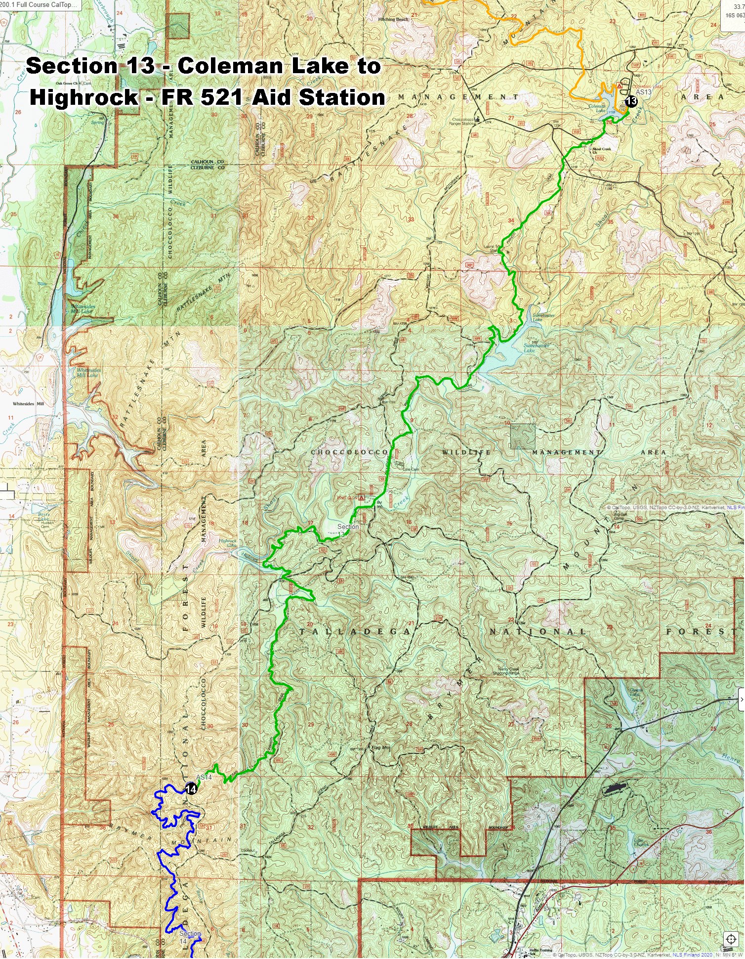

Leave the aid station, head back to FR 553D and turn left for 100 yards. Enter the Coleman Lake Loop Trail to the Left. Cross the dam and circle around the south end of the lake. The lake will be on your right. The trail connects back into the Pinhoti Trail. Runners will continue on single-track trails all the way to Highrock Aid Station at mile 168.72 on FS Road 531.
Distance Between: Coleman Lake to Highrock Aid Station – 14.60 Miles, Cumulative Miles 172.26
Elevation Change: Ascent – 630 ft., Descent – 858 ft.
Hard Packed Dirt/Gravel Roads – 0.1 miles
Single-track Trails: Total – 14.38 miles
Section 14 - Highrock to Fay’s Blowdown Aid & Sleep Station - Mile 172.26 to Mile 183.42
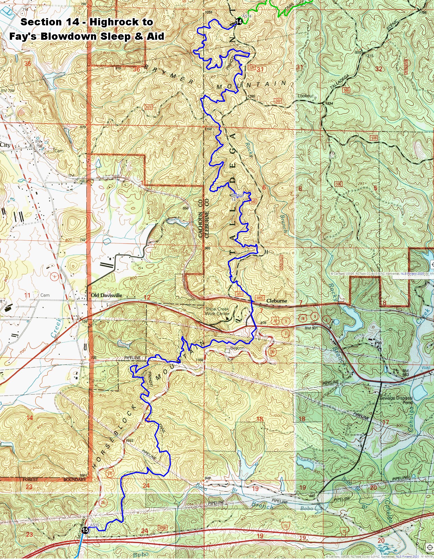

The section between Highrock and Fay’s Blowdown is all on single-track trails except for about 200 yards on a gravel road and 200 yards on pavement at Pine Glen Ranger Station and Trailhead. Immediately past Pine Glen Trailhead runners will cross railroad tracks. Be careful here. Trains come through he at high speed. Follow the gravel road for 200 yards then turn left on Hwy 281 (Skiway Mountainway) for about 200 yards. Immediately after crossing over Hwy 78, runners climb over the guardrail to continue on the Pinhoti Trail.
Distance Between: Highrock to Fay’s Blowdown Aid & Sleep – 11.16 Miles, Cumulative Miles – 183.42
Elevation Change: Ascent – 1,751 ft., Descent – 1,759 ft.
Single-track Trails: Total – 11.28 miles
Section 15 - Fay’s Blowdown to Lost Gulch Aid Station - Mile 183.42 to Mile 194.49

Leave Fay’s Blowdown Aid Station heading south on Hwy 281. Cross over Interstate-20 and continue for 200 yards and follow signs directing you back onto the single-track trail on your right. After 4.1 miles, the Pinhoti crosses US Hwy 431. This is a busy road with cars traveling 40 to 50 MPH as they pass the trail crossing. The crossing is also between two curves in the road. BE CAREFUL. Cross 431 and go to your right, continuing along the paved road for perhaps 100 feet, then turn left up to the trailhead on a dirt road for about 200 yards. The trail continues straight ahead.
After about 5 miles, the trail crosses County Rd 24. This road also crosses between two sharp turns on a downhill grade. This is a tricky area for drivers. They are focused on the road not hikers or runners. Be cautious here. At CR 24, go left about 50 ft. then back right into the woods on the Pinhoti Trail. After 1.9 miles, follow signs directing you to the left 450 yards to the Lost Gulch Aid Station.
Distance Between: Fay’s Blowdown to Lost Gulch Aid Station – 11.07 Miles, Cumulative Miles – 194.49
Elevation Change: Ascent – 2,149 ft., Descent – 2,327 ft.
Single-track Trails: Total – 11.73 miles

Section 16 - Lost Gulch to Bald Rock Lodge Finish - Cheaha State Park - Mile 194.49 to Mile 203.10
PLEASE NOTE: RUNNERS ARE REQUIRED TO CHECK IN, AND OUT OF ALL AID STATIONS. “ALL MEANS ALL.” IF YOU SHOW UP AT BALD ROCK AND DIDN’T CHECK IN AT LOST GULCH, YOU HAVE TWO OPTIONS.
1) RUN BACK TO LOST GULCH, CHECK IN, AND RUN BACK TO BALD ROCK. YOU WILL BE AN OFFICIAL FINISHER. CONGRATULATIONS, YOU JUST FINISHED THE SOUTHERN STATES 221.18!
2) DNF
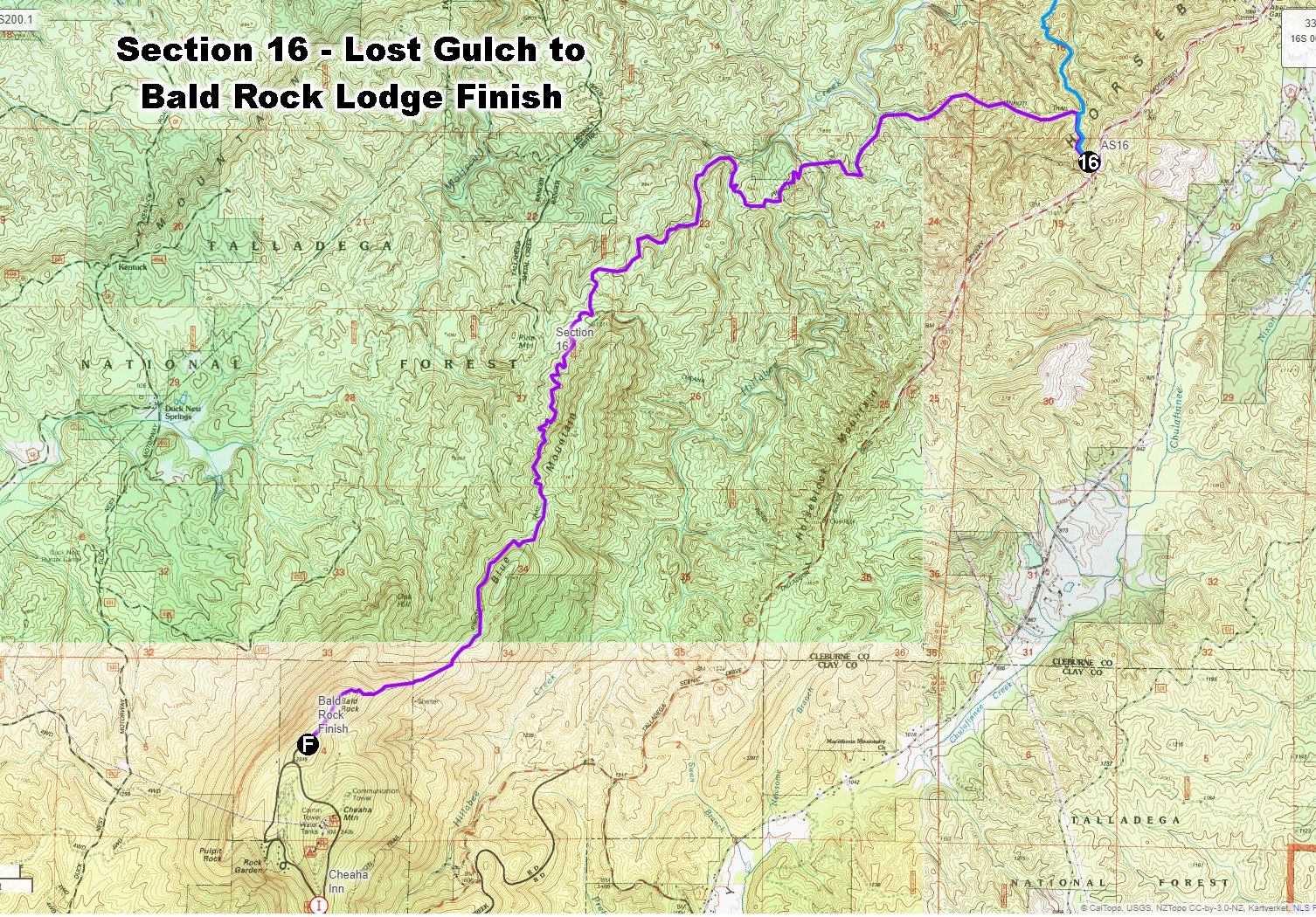

Follow the old abandoned road for single-track trail back the way you came for 450 yards to the Pinhoti Trail. Go left for 7.55 miles to a trail split. This is where the Bald Rock Trail leaves the Pinhoti Trail. The Bald Rock Trail is 0.5 Miles long and climbs 390 feet. It ends at the 1,500 foot long Bald Rock Boardwalk. Runners are not allowed on the boardwalk. Stay on the trail the parallels the boardwalk. When you reach Bald Rock, take a moment to look around. The view off to the west is amazing. The banner photo we use for the Southern States 200 was taken from Bald Rock.
Follow the boardwalk, staying on the trail to the side of the boardwalk, to the southwest. The trail will lead you directly to the finish is at the Bald Rock Lodge.
Distance Between: Shoal Creek to Morgan Lake Aid Station – 8.61 Miles, Cumulative Miles – 203.10
Elevation Change: Ascent – 2,300 ft., Descent – 1,053 ft.
Single-track Trails: Total – 9.04 miles